 |
2009 | |
| January/February | |
| Muenzenberg | Bruchenbruecken-Muenzenberg |
| Nidda-Nidder | RMV 9 |
| March/April | |
| Worms-Frankfurt | Birthday Ride |
| 3 Counties Tour | Spessart Crucifixion/Resurrection |
| Mai/Juni | |
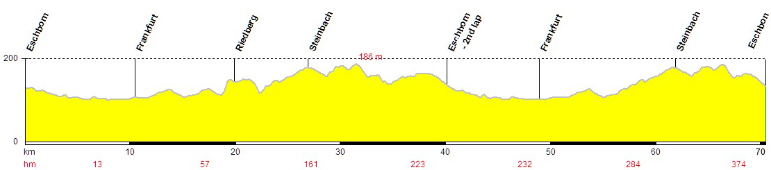
| Eschborn-Frankfurt City Loop | Nieder-Erlenbach RTF |
| Trekking: Vogelsberg/Rhön | |
| July/August | Sept/Oct |
| Traverse de France | Two days in the Vogelsberg |
|
|
 The last weekend in January, we've just had a couple of weeks of Arctic temperatures and snow - so I've been using my son's mountain-bike a lot. The snow has gone, so I decide to do a nice ride that I did last autumn: A jaunt to the ruins of the castle at Münzenberg. Alongside the River Nidda - which only 2 weeks previously had been frozen over - to Assenheim, and then with the "Rhine-Main-Pleasure 2" theme route (mostly farm roads/tracks in excellent condition), up to and round the mighty castle before heading back down to Friedberg to take the train back towards home. The last weekend in January, we've just had a couple of weeks of Arctic temperatures and snow - so I've been using my son's mountain-bike a lot. The snow has gone, so I decide to do a nice ride that I did last autumn: A jaunt to the ruins of the castle at Münzenberg. Alongside the River Nidda - which only 2 weeks previously had been frozen over - to Assenheim, and then with the "Rhine-Main-Pleasure 2" theme route (mostly farm roads/tracks in excellent condition), up to and round the mighty castle before heading back down to Friedberg to take the train back towards home.
|

|
 |
|
|

|
Having discovered a useful train connection I've moved my "starting point" for rides recently. A 5-mile ride to the station, hop on for 15 mins and I'm out in the Wetterau. In Bruchenbrücken to be precise. Now there's a name to conjure with. I wanted to cycle to Munzenberg again, this time from the opposite direction as there's a nice gentle 2-3 km hill up to the castle. Time to start getting the legs used to those long climbs! I added a little loop at the beginning to "recce" the local routes. I think I'm going to permanently move my starting point for when I ride out here.
|
|
|
|
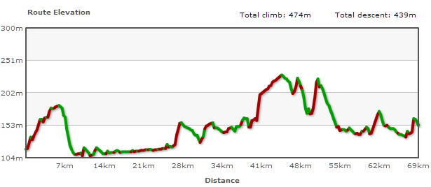
 Another start from Bruchenbrücken. This time along the Nidda to the eponymous town (puncture stop, thank God it's started to warm up a bit on this crisp Sunday morning) and then over the steep hills into the valley of the River Nidder. First stop of the year at Cafe Frech in Ortenberg! Then along the Vulkan cycleway for 30 km or so before the long haul time up the hill back into Frankfurt. Slowly getting used to those hills again! By the way, the last 6 km on the map/profile are actually the first 6 km to the train station. Another start from Bruchenbrücken. This time along the Nidda to the eponymous town (puncture stop, thank God it's started to warm up a bit on this crisp Sunday morning) and then over the steep hills into the valley of the River Nidder. First stop of the year at Cafe Frech in Ortenberg! Then along the Vulkan cycleway for 30 km or so before the long haul time up the hill back into Frankfurt. Slowly getting used to those hills again! By the way, the last 6 km on the map/profile are actually the first 6 km to the train station.
|

|
|
|
|

|
 I noticed signs for this new route from the local rail/bus company while out cycling by the River Main recently so I sent them an e-mail and they sent me a whole pack of free maps for their routes. Didn't prompt me to use the train this time mind! The start is only 20 km from home and flat most of the way. The RMV9 route mostly follows paths along little rivers and through woods to the pretty little town of Seligenstadt, then through more woods back to the start. This was a nice 100 km ride with sunshine and snow, and lots of wind on the last 30 km along the River Main. That should help get me fit for the re-branded version of our local "Everyman Race" on May 1 - my first target for the year. I noticed signs for this new route from the local rail/bus company while out cycling by the River Main recently so I sent them an e-mail and they sent me a whole pack of free maps for their routes. Didn't prompt me to use the train this time mind! The start is only 20 km from home and flat most of the way. The RMV9 route mostly follows paths along little rivers and through woods to the pretty little town of Seligenstadt, then through more woods back to the start. This was a nice 100 km ride with sunshine and snow, and lots of wind on the last 30 km along the River Main. That should help get me fit for the re-branded version of our local "Everyman Race" on May 1 - my first target for the year.
|
|
|
|


|
|
|


|
|
|
|
 The weekend before Easter, the various members of the family are away for a few days and so it's time for the mouse to play ... Out comes the Koga Miyata and off I go on the "3 Laender" cycle-way. This route takes in 3 German states: Hesse, Baden-Wuerttemberg and Bavaria (the "3 Counties Tour" seems a more appropriate title than the "3 States Tour" given the plethora of new states that has appeared in Europe in recent years). I took the train out of Frankfurt at the start, saving me a flat 40 km ride as I knew I had to get over the "Radheim Alps" to join this circular route at Hoechst in the Odenwald. The weekend before Easter, the various members of the family are away for a few days and so it's time for the mouse to play ... Out comes the Koga Miyata and off I go on the "3 Laender" cycle-way. This route takes in 3 German states: Hesse, Baden-Wuerttemberg and Bavaria (the "3 Counties Tour" seems a more appropriate title than the "3 States Tour" given the plethora of new states that has appeared in Europe in recent years). I took the train out of Frankfurt at the start, saving me a flat 40 km ride as I knew I had to get over the "Radheim Alps" to join this circular route at Hoechst in the Odenwald.
While crossing the Radheim Alps the integrated compass on the bike's bell again comes in very handy - I soon realize that it isn't Jack Sparrow's compass but that some locals have in fact twisted the signpost around by 90 degrees, thus sending me off on a short circular detour! Once over these hills, it is all pleasant going alongside the pretty River Muemling until shortly after Erbach. Suddenly the path is mostly gravel-packed tracks through woods and is very hilly indeed. Well if it don't kill me, it can only make me stronger (and hungrier and thirstier ...). About now two things go through my mind: 1. An alternative to all these "world tours" people do. Being more of a fan of Europe, why not cycle to all the European Olympic cities (summer + winter)? 2. On a more pressing note. I've forgotten to pack my trousers! Buggered if I'm going to get to my bed & breakfast, have a shower then put my sweaty cycling shorts back on again. Trousers Grommit! Luckily I do manage to buy some in Hirschhorn. |

")
|
 Schaafheim Watchtower |
 Schaafheim Watchtower |
 Steinbach Schloss Fuerstenau |
 Erbach Houses next to the River Muemling |
 Erbach Chateau |
 Hetzbach Himbaechl Viaduct |
| On the first day I specifically missed out a few of the so-called tourist highlights such as Michelstadt as I had been there once before. When out on my bike I prefer to ride rather than stop and take lots of photos, look for the perfect shot etc. And a camera is not really the ideal tool for capturing the complete atmosphere of cycling through beautiful countryside. Likewise it's almost impossible to photograph just how steep a hill is, what it means to make it to the top, or how exhilarating it is to cycle down steep tracks such as the one into Hirschhorn (it was almost a "single trail", real mountain biking, but with 12 kilos of assorted luggage in this case!). Hirschhorn on the River Neckar is very pretty, the most southerly town in the state of Hesse, but my thoughts are more on the nearest bakery, a well-deserved alc-free beer and a cigarette at last. Then it's up the hill to the next village and my guest-house for the night, a revitalising shower, a hearty meal and a good night's sleep after all those steep climbs.
More "touristy" photos of places along the route can be found using Google Earth and Panoramio. activate the Panoramio button under "Geographic Web" in the "Layers" panel. |

|
| Day Two starts with that most vital part of a day's cycling - a bloody good breakfast! You've got to hand it to these country folk, they know how to look after their guests. You always seem to get treated much better once you leave the beaten track. By nine o'clock I'm on the road and heading towards the state of Baden-Wuerttemberg. Mercifully no sign of any tired muscles after yesterday's efforts. It's a beautiful morning with lots of mist on the densely wooded hills as I ride back down into Hirschhorn and along the cycle-way next to the River Neckar. All very flat (as you'd expect!), which is just as well given the fact that it is mostly forest paths and farm tracks. After about 40 km I pass the site of Neckarelz concentration camp. It's in a residential area (and was at "that" time)! I make a mental note to read up on it when I get home. Dark thoughts accompany me for a while. Fortunately I soon recall the words of my grandfather (who spent six long years as a very young man fighting for the Allies and saw more things than he could care to remember, including many acts of barbarism by the allied troops): "There are good bastards and bad bastards on both sides!" While it often seems to be human nature to forget quickly rather than forgive easily, the world would be a better place if it we all forgave quickly while making sure we don't forget. Anyways, that's enough amateur philosophy, let's get back to the cycling ...
I soon arrive in Mosbach, a beautiful town, but being Saturday and a packed market day there is no chance of getting in any decent photos of the wonderful half-timbered buildings. I settle for a refuel instead: Delicious apple strudel and coffee. And then comes the bit I've really been looking forward to - the Odenwald Wanderbahn cycle-way, a disused narrow-gauge railway line/track (very little asphalt unfortunately) that gently climbs about 300 metres in height over 20 kilometres to the little town of Mudau. Once there I take a break at a pub for some French fries and a refreshing alc-free beer, it's 35 degrees in the sun after all. I get into a conversation with the landlord, and when I tell him where I'm heading he informs me that the road down to the valley of the River Main has recently been re-asphalted. This would mean leaving my intended route. But what the hell, being able to change horses in midstream is what travelling on your own is all about. After all the rough tracks in the past day and half it will make a pleasant change. The road is a beauty. 7 metres wide - so not much danger is likely to be posed by overtaking cars - and virgin asphalt that has just been waiting for me! The ten-kilometre downhill descent is a dream with relatively gentle corners. Later I saw I'd managed a top speed of 65 kmh here. So now I'm into the third state of this tour, Bavaria. I decide to skip the next "tourist trap", Miltenberg, as I've been there a few times before. I follow the cycle-way along the River Main, stopping to take a few photos and enjoy an ice-cream in Obernburg. Now the pressing question. Where shall I stay tonight? In theory I could make it home to my own bed by nightfall, but I've slept in that a few times before too. Departing from my intended route again, I decide to head over the River Main into the Spessart region. They have hills there too - in fact they have very little else. I reach a village after a steep climb and soon find a place for the night. Very comfy - and cheap. A double room with shower, TV, 2 alc-free beers, a pack of cigarettes, a great breakfast the next morning and tons of food to take for the day cost a mere 32 euros! |
 Hirschhorn Church that was once a city gate |
 Hirschhorn Castle silhouetted in the morning mist |
 Zwingenberg Castle set on a hill above the Neckar |
 Amorbach The River Mud (strange to English ears) |
 Amorbach Impressive church |
 Woerth am Main City gate |
 Woerth am Main Impressive bit of architecture |
 Obernburg am Main Almosenturm "Alms Tower" |

| Day Three. After the fortifying breakfast I decide to head to a nearby Bicycle Museum in Heimbuchenthal. Closed for renovations alas. The route I'm taking now follows the pretty River Elsava, with little wooden bridges connecting people's houses to the village streets. As I climb the hills it's easy to see why the Spessart region is known as "highwayman country", it seems to be entirely made up of dark valleys and steep hills, and it's very sparsely populated. Every village seems to have a pub called the "Woodpecker's Arms" (should be the "Woodpecker's Wings" I suppose, but it wouldn't have the same ring about it in English). It's easy to hear why. I even spot of couple of them pecking away at trees, and I even see the odd heron or two. The people also seem to be a pious lot here. The Catholic influence is very clear to see. Almost every house has a recess in the wall accommodating a statue of the Madonna or a crucifixion scene. The number of wayside shrines is also mind-boggling. I've seen lots of these on my travels through Franconia and the Rhoen area. But here there seem to be almost as many of these shrines as houses. On a slightly blasphemous aside: A bit of the tour took in the Odenwald Madonna Route, which set me thinking and humming: Like a virgin - Ridden for the very first time.
A stop for coffee ("fuelling cyclists for generations") and a thick lashing of sun cream is called for when I reach Sailauf. You can tell it's a Sunday, the cyclists are out in force. Methinks it best to head into the hills again and get away from them all. Funny that. None to be seen once it starts getting hilly. Conscious of the fact that I have to get home at some point I head towards Seligenstadt where I can take the ferry over the River Main and back into the state of Hesse. The ferry is packed, as is Seligenstadt. Time for the first iced coffee of the year and then get away from all these people, and more specifically the cluttered cycle paths. This is where all those winter rides prove their worth (was it really only eight weeks ago that I was riding through the snow here?). I know the routes without having to consult a map, and don't have to contend with the masses wobbling along on two wheels. |

| Postscript: A great little tour. I'd recommend it to anyone who can cope with the hills. The state of the cycle-ways/tracks (pretty rough in parts) has confirmed that I did the right thing in getting a trekking bike for such tours. And it is only fair that I publicly thank my good wife for presenting me with such a wonderful birthday gift.
What would I do again? 1. Always seek out little villages if staying in bed and breakfast places - so much cheaper than towns and cities. 2. Always take my daughter's cheaper digital camera. It might not take such good photos, but it's nearly half a kilo lighter and does the job just as well at the end of the day. What would I do differently? 1. Carefully lay out all my gear before packing it and then tick things off the list as they go into the panniers! 2. Take a careful passing glance at signposts to see if the hinges look broken/bent - I was lucky my bell has an integrated compass and was very sure of my intended direction of travel. As it was it merely cost me a 5 km detour with one repeated hill. Under other circumstances it could have been a very long and arduous detour. 3. Stop humming "Like a virgin"! |
|
|
|
 |
Easter, Good Friday to boot, so what could be more apposite for a Christian (which, much less appropriately, is my surname) than a little crucifixion in the Spessart? Off into the beautiful countryside with 5 others on racing bikes, all starting with a 20-minute train ride out of town from Frankfurt East station. Perhaps the most dilapidated station you'll ever see. If you knew no better, you'd think it was closed down. That was the only photo I took all day - too busy trying to keep up with the fitter, younger blokes on the hills.  And too busy enjoying the views when things flattened out (those trees coming into glorious blossom!). It's hot to boot, average temperature of 25 degrees. So after some 70 km we take a break for some refreshment at a pub. It's amazing how regenerating a couple of alc-free "Hefeweizen" - a yeasty beer brewed with wheat, the best isotonic drink ever - can prove to be. Just as well as the highest point of the day comes next. We pass a couple in their forties on ordinary bikes heading up the hill. Best not to say "Good day". I know from personal experience there's nothing more dispiriting than having someone seemingly whizz past you going uphill, only to find they still have the breath to let out more than a groan. I mentally tip my helmet to them instead. My legs are crucifying me, but we are soon rewarded with an expansive panorama of the Kinzig Valley as we glide down through Waldrode towards home territory. Up over a hill - which mercifully now seems relatively small - and the familiar sight of Ronneburg Castle looms into view. Only two last hills to rub vinegar into the wounds. Let's just hope there'll be a resurrection ... And too busy enjoying the views when things flattened out (those trees coming into glorious blossom!). It's hot to boot, average temperature of 25 degrees. So after some 70 km we take a break for some refreshment at a pub. It's amazing how regenerating a couple of alc-free "Hefeweizen" - a yeasty beer brewed with wheat, the best isotonic drink ever - can prove to be. Just as well as the highest point of the day comes next. We pass a couple in their forties on ordinary bikes heading up the hill. Best not to say "Good day". I know from personal experience there's nothing more dispiriting than having someone seemingly whizz past you going uphill, only to find they still have the breath to let out more than a groan. I mentally tip my helmet to them instead. My legs are crucifying me, but we are soon rewarded with an expansive panorama of the Kinzig Valley as we glide down through Waldrode towards home territory. Up over a hill - which mercifully now seems relatively small - and the familiar sight of Ronneburg Castle looms into view. Only two last hills to rub vinegar into the wounds. Let's just hope there'll be a resurrection ...
|

|
|
|
 Same train, different route, 
|

Open route using Google Earth |
|
|
|
|


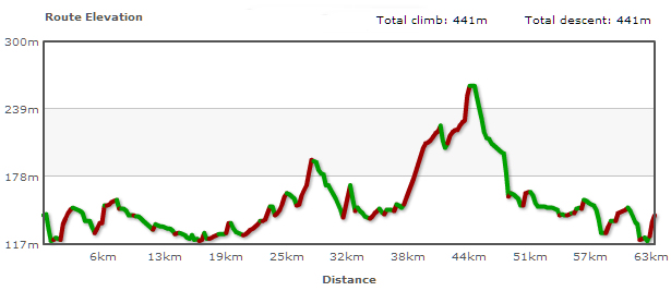
 The next day I headed up higher into the hills, mostly through woodland and along mountain bike trails in search of the source of the River Nidda. Not a soul to be seen or heard for the first hour. Absolute bliss. I soon manage to find the source of the Nidda. Not that impressive, nothing more than a trickle of water - but then that was to be expected. From here I cycle on to the Hoherodskopf, the highest point of the tour, before heading towards Hartmannshain, where I join the Vulkanradweg for a fast downhill ride through the woods (the cycle-way is asphalted!) to Ortenberg and my favourite cafe for a well-deserved cuppa and piece of cake before tackling the final 50 km back home.


