 |
2011 |  |
|
|
| March/April | |
| Tour de Hesse | |
| Mai/Juni | |
| Kocher and Jagst | |
| July/August | |
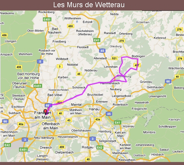
| Les Murs de Wetterau | |
| Alsace | |
| September | |
| Collecting Alsatian cols |
|
|
 |
|
|
|
|
 |
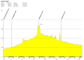
Day 1, 40 km |
 Forchtenberg: Brunnentor |
 Forchtenberg: Brunnentor |
 Forchtenberg: The "Tea House" - a very up-market garden shed |
 Forchtenberg: River Kocher |
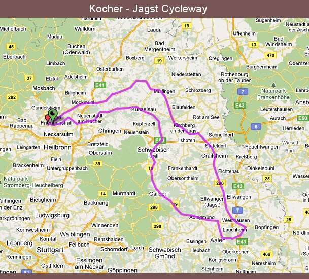
Day 2, 130 km, 1000 meters of climbing Glorious sunshine but a cool headwind today. Not long after setting off I pass by a decommissioned railway wagon that is now used as a hotel "room" - must try that out some time. The usual array of beautiful half-timbered buildings in the villages - above all what was the school attended by Götz von Berlichingen (see photo left) and the town hall in Künzelsau (see photo right). Glorious sunshine but a cool headwind today. Not long after setting off I pass by a decommissioned railway wagon that is now used as a hotel "room" - must try that out some time. The usual array of beautiful half-timbered buildings in the villages - above all what was the school attended by Götz von Berlichingen (see photo left) and the town hall in Künzelsau (see photo right). At one point I pass under Europe's highest motorway viaduct before continuing to battle the headwind (ironically enough the prevailing wind would normally be a backwind - but it would be a case of the pot calling the kettle black if I were to complain about the wind!) and head on towards Schwäbisch Hall. A very beautiful town - famed for its architecture, and above all for the steps in front of St Michael's Church. After a coffee and photo break it's back on the road - and the wind starts to get annoying, as does the fact that the cycleway always seems to run close to a road. Mercifully I'm joined by a bloke on his mountain bike who offers me a lot of protection from the wind. We also have time to get chatting - it turns out he was an "A" licence amateur rider (the standard closest to being a pro) till his knee packed up. No wonder he's so fit. He accompanies me for nearly two hours - and very pleasant company he was too. I take a coffee break in Aalen before bidding the river Kocher farewell and heading over a big hill towards the Jagst valley. Again no campsite for miles so I have to take a room in a pricey hotel. Still, the food in their restaurant is excellent. And tasted all the better for the fact that they forgot to add it to my bill the next day when it was time to pay. Not so pricey after all then. At one point I pass under Europe's highest motorway viaduct before continuing to battle the headwind (ironically enough the prevailing wind would normally be a backwind - but it would be a case of the pot calling the kettle black if I were to complain about the wind!) and head on towards Schwäbisch Hall. A very beautiful town - famed for its architecture, and above all for the steps in front of St Michael's Church. After a coffee and photo break it's back on the road - and the wind starts to get annoying, as does the fact that the cycleway always seems to run close to a road. Mercifully I'm joined by a bloke on his mountain bike who offers me a lot of protection from the wind. We also have time to get chatting - it turns out he was an "A" licence amateur rider (the standard closest to being a pro) till his knee packed up. No wonder he's so fit. He accompanies me for nearly two hours - and very pleasant company he was too. I take a coffee break in Aalen before bidding the river Kocher farewell and heading over a big hill towards the Jagst valley. Again no campsite for miles so I have to take a room in a pricey hotel. Still, the food in their restaurant is excellent. And tasted all the better for the fact that they forgot to add it to my bill the next day when it was time to pay. Not so pricey after all then. |
 Schwäbisch Hall: Impressive fountain |
 Schwäbisch Hall: Amazing flight of steps |
 Schwäbisch Hall: Half-timbered houses |
 Schwäbisch Hall: River Kocher |
Day 3, 110 km, 700 meters of climbing After that pleasant little After that pleasant little surprise when I paid my bill I decide to take the main road rather than the somwhat circuitous and hilly cycleway down to the river Jagst. I pass the mammoth Kapfenburg Castle (unfortunately as I'm zooming downhill so no photo) before reaching Lauchheim with its impressive town gate. The cycleway is really gorgeous and very quiet, a real contrast to yesterday afternoon and the traffic so close to the Kocher cycleway. Lots of traces of the "Limes", the old Roman fortifications, along the route. I stop for coffee and a liberal dashing of sun-cream in Ellwangen and Crailsheim (very hot and the wind is deceptive). From Crailsheim onwards the route gets very hilly - but great views, and especially around the old town of Kirchberg perched on a hill above the valley. I also pass a lovely old covered bridge, of which there seem to a lot in the region. After an hour or so of going up and down hills I reach my campsite for the night surprise when I paid my bill I decide to take the main road rather than the somwhat circuitous and hilly cycleway down to the river Jagst. I pass the mammoth Kapfenburg Castle (unfortunately as I'm zooming downhill so no photo) before reaching Lauchheim with its impressive town gate. The cycleway is really gorgeous and very quiet, a real contrast to yesterday afternoon and the traffic so close to the Kocher cycleway. Lots of traces of the "Limes", the old Roman fortifications, along the route. I stop for coffee and a liberal dashing of sun-cream in Ellwangen and Crailsheim (very hot and the wind is deceptive). From Crailsheim onwards the route gets very hilly - but great views, and especially around the old town of Kirchberg perched on a hill above the valley. I also pass a lovely old covered bridge, of which there seem to a lot in the region. After an hour or so of going up and down hills I reach my campsite for the night in a nook of the river just a few kilometers from the town of Langenburg - which is set high up on the hill above the valley (as indeed are most of the towns and villages along the Jagst). So it's up with the tent and then up the hill without any luggage - a real joy because the view from the town down into the valley is just as impressive as the town itself. in a nook of the river just a few kilometers from the town of Langenburg - which is set high up on the hill above the valley (as indeed are most of the towns and villages along the Jagst). So it's up with the tent and then up the hill without any luggage - a real joy because the view from the town down into the valley is just as impressive as the town itself. |
 Langenburg: Town gate |
 Langenburg: Bächlingen down in the valley |
 Langenburg: Weird clock-tower |
Day 4, 100 km, 300 meters of climbing Another gorgeous day Another gorgeous day with glorious sunshine - but still a headwind alas. Again the landscape is dominated by villages and towns above the valley. And once again the usual array of half-timbered buildings. By far the most interesting sights along the route are the town of Möckmühl - I would have taken some photos but a shower rather scotched that plan - and a monastery by the name of Kloster Schöntal - where a wedding was taking place so again no photos. I'm definitely coming back here one day. In Krautheim (great name for a German town, eh?) I pass by a statue of Götz von Berlichingen, one of medieval Germany's most colourful characters and the man credited with coining the expression "Leck mich am Arsch", which broadly translates as "kiss my arse", and euphemistically known as the Swabian greeting. The sound of distant thunder prompts me to pedal on quite quickly, however, and catch a late train home rather than searching for a campsite for the night. with glorious sunshine - but still a headwind alas. Again the landscape is dominated by villages and towns above the valley. And once again the usual array of half-timbered buildings. By far the most interesting sights along the route are the town of Möckmühl - I would have taken some photos but a shower rather scotched that plan - and a monastery by the name of Kloster Schöntal - where a wedding was taking place so again no photos. I'm definitely coming back here one day. In Krautheim (great name for a German town, eh?) I pass by a statue of Götz von Berlichingen, one of medieval Germany's most colourful characters and the man credited with coining the expression "Leck mich am Arsch", which broadly translates as "kiss my arse", and euphemistically known as the Swabian greeting. The sound of distant thunder prompts me to pedal on quite quickly, however, and catch a late train home rather than searching for a campsite for the night.
All in all a very pleasant trip - and especially along the river Jagst - it is just a shame that there aren't more campsites. Above all I'm glad I cycled the Kocher first and then the Jagst - it's always nice to save the best bits for last. |
 |
|
|
 |
|
|
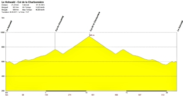
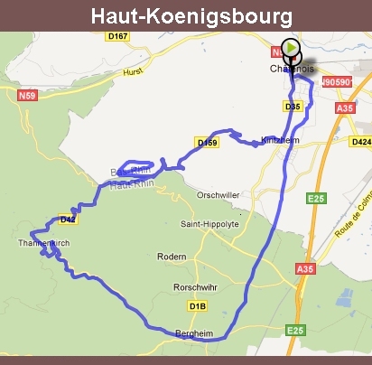
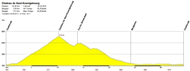
 Not so much of a cycling trip, rather a short break with better half and our bikes on the back of the car (add a mental comma to that sentence: only the bikes were on the back). We'd only been to the Alsace region of France once before - can't think why we never came back before now. Great food, tasty wines, impressive views of the hills and mountains, and very ridable climbs they are too. Three days cycling around, from one beautiful little wine village to the next. A couple of car jaunts to the fortified town of Neuf-Brisach (Vauban's last major work if I remember correctly) and the medieval castle of Haut-Koenigsbourg (lovingly restored by the "Kaiser" through to 1908 and then taken away from Germany under the Versailles Treaty of 1919). And one morning I even managed to fit in a tasty hill climb with lots of hairpins before breakfast. Not so much of a cycling trip, rather a short break with better half and our bikes on the back of the car (add a mental comma to that sentence: only the bikes were on the back). We'd only been to the Alsace region of France once before - can't think why we never came back before now. Great food, tasty wines, impressive views of the hills and mountains, and very ridable climbs they are too. Three days cycling around, from one beautiful little wine village to the next. A couple of car jaunts to the fortified town of Neuf-Brisach (Vauban's last major work if I remember correctly) and the medieval castle of Haut-Koenigsbourg (lovingly restored by the "Kaiser" through to 1908 and then taken away from Germany under the Versailles Treaty of 1919). And one morning I even managed to fit in a tasty hill climb with lots of hairpins before breakfast.
|
 Ammerschwihr |
 Hunawihr |
 Katzenthal |
 Haut-Koenigsbourg |
 Bergheim |
 |
|
|
 Chatenois |
 Chatenois |
 Chatenois - My humble abode for the night |
 Chatenois - Witches Tower |
 Chatenois |
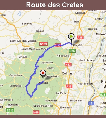
| Day 3 - Saturday The days starts with a shock. Thick fog as I settle down for breakfast. Ignore it, it'll go away. I do and it does. To be replaced by glorious sunshine. Just as well since today is the day the teddy bears have their picnic. In the form of the Route des Cretes, the road running more or less along the main ridge of the Vosges Mountains.  But first of all I have to get up there. I ride along the Val d'Argent (Silver Valley, this is a former mining region), stopping for a coffee and a lashing of sun cream before the climb starts proper in Sainte-Marie-aux-Mines. It's a nice quiet road next to a little river/big stream, and after 6 km there come a couple of switchbacks and lots of tree cover. Mercifully, because I'm already sweating buckets. Suddenly the cover breaks and I'm at the head of the valley. And what a view! A photo or two and then for some more climbing and the other cols on the route. Shortly before Col du Calvaire I can see bikes hanging from the ski-lift as it comes up the hill - mountain bikers, at least a hundred are waiting to hit a downhill course here. One way of getting back up the hill I suppose. Calvaire also marks the end of the treeline and the quiet road. Sun, wind and motorbikes are now my constant companions. Some great views though. Some pesky wasps too. They quite spoilt my coffeine doping stop at Col de la Schlucht. I head down to Munster at Col du Platzerwasel (I'm glad I'm not coming up this hill, one section has a gradient of 12% for about 2 km!). Once off the mountains, the valley has a nice cycle-path, taking me all the way to Munster, which abounds in the region's trademark storks - one building has 10 nests, all in use. But first of all I have to get up there. I ride along the Val d'Argent (Silver Valley, this is a former mining region), stopping for a coffee and a lashing of sun cream before the climb starts proper in Sainte-Marie-aux-Mines. It's a nice quiet road next to a little river/big stream, and after 6 km there come a couple of switchbacks and lots of tree cover. Mercifully, because I'm already sweating buckets. Suddenly the cover breaks and I'm at the head of the valley. And what a view! A photo or two and then for some more climbing and the other cols on the route. Shortly before Col du Calvaire I can see bikes hanging from the ski-lift as it comes up the hill - mountain bikers, at least a hundred are waiting to hit a downhill course here. One way of getting back up the hill I suppose. Calvaire also marks the end of the treeline and the quiet road. Sun, wind and motorbikes are now my constant companions. Some great views though. Some pesky wasps too. They quite spoilt my coffeine doping stop at Col de la Schlucht. I head down to Munster at Col du Platzerwasel (I'm glad I'm not coming up this hill, one section has a gradient of 12% for about 2 km!). Once off the mountains, the valley has a nice cycle-path, taking me all the way to Munster, which abounds in the region's trademark storks - one building has 10 nests, all in use.
|
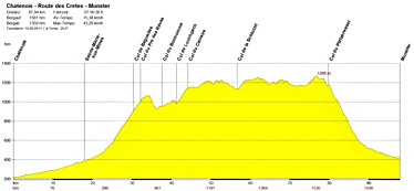 |
 Col des Bagenelles |
 Col du Pré de Raves |
 Col du Bonhomme |
 Col du Louchpach |
 Col du Calvaire |
 Col de la Schlucht |
 Col du Platzerwasel |
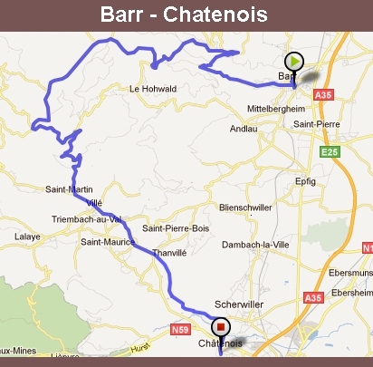
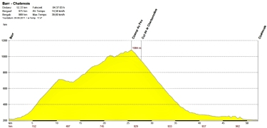
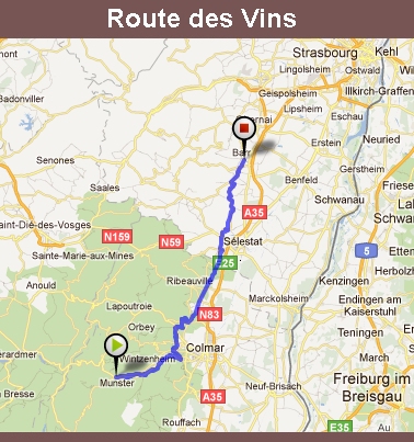
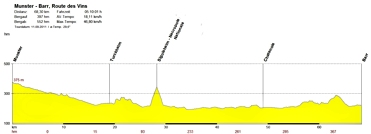
Day 4 - Sunday Although it's a lovely looking morning, my aching legs are demanding plan B: No big hills! I exchange a few stern words with legs, who have now started complaining that breakfast is just a bit too "continental" for their liking, finally managing to negotiate a route through the vineyards, calling in at Sigolsheim (legs are obviously not on speaking terms with eyes, who already know what this means). Again there is a nice cycle-way along the valley and I am soon in Turckheim, another Although it's a lovely looking morning, my aching legs are demanding plan B: No big hills! I exchange a few stern words with legs, who have now started complaining that breakfast is just a bit too "continental" for their liking, finally managing to negotiate a route through the vineyards, calling in at Sigolsheim (legs are obviously not on speaking terms with eyes, who already know what this means). Again there is a nice cycle-way along the valley and I am soon in Turckheim, another beautiful village. Then it's through the vineyards (lot of mumbling from legs), past the delightful Katzenthal, and to Sigolsheim for the only major hill of the day - up to the war cemetery. The hill rears its head, eyes light up, legs resign themselves to the fact they've been tricked. It's a beautiful view from the top, albeit in a sobering setting. Once down the hill the cycle-way continues through the vineyards and back lanes. After a spot of lunch in Chatenois, I join the hilly road to Barr (more mumbling from legs), where the car awaits (rain/storm forecast for tomorrow) and hopefully I'll be back home in time for tea. Legs are not happy at all now: "We take you up and down hills for 4 days and you expect us to drive you home as well?" I won't repeat what arse had to say about the prospect of being flattened for another 2-3 hours! There's just no pleasing some body parts. beautiful village. Then it's through the vineyards (lot of mumbling from legs), past the delightful Katzenthal, and to Sigolsheim for the only major hill of the day - up to the war cemetery. The hill rears its head, eyes light up, legs resign themselves to the fact they've been tricked. It's a beautiful view from the top, albeit in a sobering setting. Once down the hill the cycle-way continues through the vineyards and back lanes. After a spot of lunch in Chatenois, I join the hilly road to Barr (more mumbling from legs), where the car awaits (rain/storm forecast for tomorrow) and hopefully I'll be back home in time for tea. Legs are not happy at all now: "We take you up and down hills for 4 days and you expect us to drive you home as well?" I won't repeat what arse had to say about the prospect of being flattened for another 2-3 hours! There's just no pleasing some body parts.
|
 |
 |
|
|
 Another tour that I have finally managed to get under my belt after rain had scotched my plans last year - the cycleway along the Kocher and Jagst rivers in Swabia. These two rivers rise only a few kilometers apart from one another and then run almost parallel before feeding into the river Neckar less than 5 kilometers from one another. All of the guide books for the cycleway(s) describe the route by riding up the Jagst and then back down the Kocher. When I arrived by train in Bad Friedrichshall near the River Neckar late one Wednesday afternoon, I opted (purely on a whim) to do it the other way round - a decision that proved to be quite fortuitous.
