 |
2007 | |
|
|
| Nieder-Weisel RTF | Bischofsheim RTF |
| Rund um den Henninger Turm | Nieder-Erlenbach RTF |
| Langenselbold RTF | Oberstedten RTF |
| Oppershofen RTF | Henninger Radler RTF |
| Havelland | Wolds Tour 1 |
| Wolds Tour 2 |
|
|
| The big highlight of 2007 for me was the "Everyman Race" as part of the Rund um den Henninger Turm race - 18 months after I had been lying in agony in hospital with severe paralysis of the right leg. If I had to choose a "great day" in my life, one that really beats all the others, I couldn't. But this one would certainly be on the short list. |
| By way of explanation: I like to do what Germans
call RTFs - Radtourfahren - which the French call "cyclotourisme" and the Brits "sportives". They're
basically routes marked out in advance by cycling clubs, usually 5 different
courses with distances ranging between 40 and 200 km at the same event.
They are not races, the roads are not closed to traffic, and riders start
the course at any time they wish on the day. There are feeding stations
and check-in points every 30 km or so - always a welcome sight. Generally
held on a Sunday and with a couple of hundred particpants and more as a
rule, an "RTF" is a great way to spend the day.
|
|
|

|
|
 |
|
|
|

|
|
|
|

|
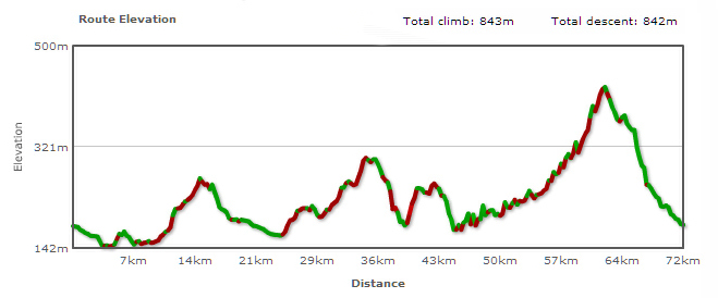
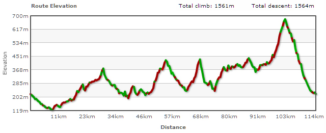
This annual classic for professionals is held
in Frankfurt on May 1, with various courses for hobby cyclists using parts of the actual route ridden later in the day by the professionals. The great thing is the fact the roads are closed to traffic - advisable
really with 3000 cyclists and 800 inline skaters tearing along. And this is it. Race day. Can I achieve my goal of an average speed of 30 kmh? A 15 km ride to the start is the perfect warm-up. The riders doing the longer (100 km) course set off first, then it's our turn. Lots
of big groups mean plenty of slipstreaming. Lots of people lining the course
mean plenty of motivation. Fast speeds in groups going into corners mean
plenty of adrenaline. Two and a quarter hours go by in a very long flash. I actually managed an average speed of 30 kmh (just under 20 mph). The best riders averaged well over 40 kmh! and 800 inline skaters tearing along. And this is it. Race day. Can I achieve my goal of an average speed of 30 kmh? A 15 km ride to the start is the perfect warm-up. The riders doing the longer (100 km) course set off first, then it's our turn. Lots
of big groups mean plenty of slipstreaming. Lots of people lining the course
mean plenty of motivation. Fast speeds in groups going into corners mean
plenty of adrenaline. Two and a quarter hours go by in a very long flash. I actually managed an average speed of 30 kmh (just under 20 mph). The best riders averaged well over 40 kmh!
 |
|
|
|
|

|
|
|
|

|
|
|
|
|
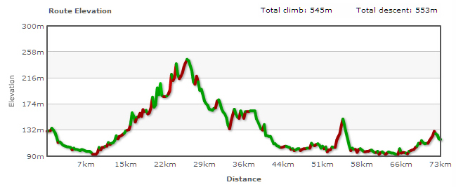
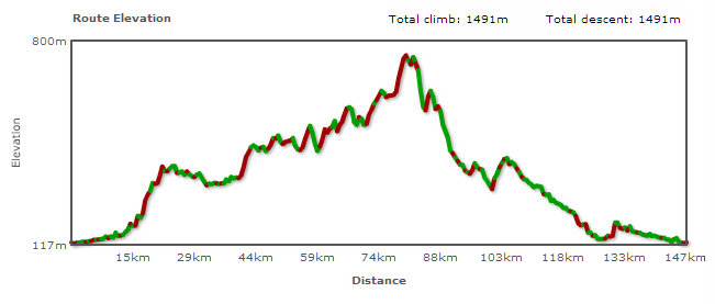
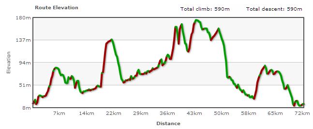
Another long ride with plenty of climbing to be done, culminating in a ride up to the "Sandplacken" - compensated for by a long downhill section at the very end. |

|
|
|
|

|
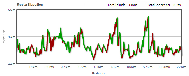
I was actually going to do a longer course, so the night before I'd eaten plenty of pasta in preparation. I got up on the Sunday morning at 6ish and looked out the window. Rain. Persisting it down. Ah well, methinks, better shift some of that pasta. At least the rain let up a bit. Still a pretty wet 75 km mind. And the other cyclists are few and far between. No streamlining today! |
|
|
|
|

|
|
|
|

|
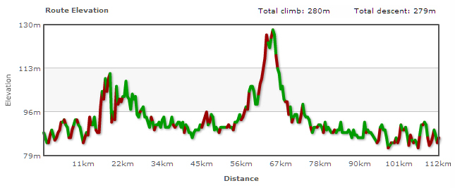
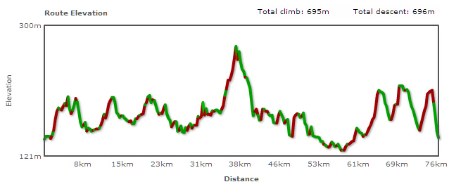
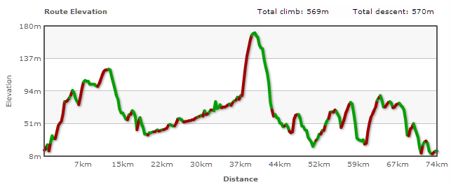
I did this little tour whilst
on holiday in what was eastern Germany. I'd already done 50 km before breakfast
(just a little detour on my way to the bakery!) and after  a leisurely breakfast
I felt like having a longer ride ... Pretty flat countryside, quite sparsely
populated in parts, with lovely tree-lined avenues. I included a section
of the Havelland
Cycleway which goes though the Luch, a sort of marsh area with
lots of rare wildlife. The ride was marred only slightly by a 20-minute stop to repair a puncture
after about 70 km. Here are some of the photos I took of the region: Havelland
photos. a leisurely breakfast
I felt like having a longer ride ... Pretty flat countryside, quite sparsely
populated in parts, with lovely tree-lined avenues. I included a section
of the Havelland
Cycleway which goes though the Luch, a sort of marsh area with
lots of rare wildlife. The ride was marred only slightly by a 20-minute stop to repair a puncture
after about 70 km. Here are some of the photos I took of the region: Havelland
photos.
|
|
|
|
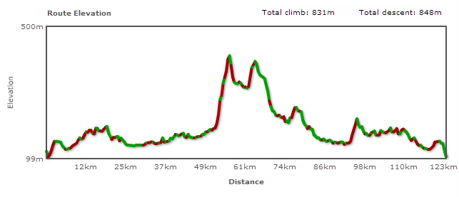
Whenever I'm home in England I like to get a bike out and cycle up and down the Wolds. There is something invigorating about those rolling hills and the occasional glimpse of the sea. |

|
|
|
|

|
Boxing Day 2007. The day everyone goes for walk with their loved ones and family. I went for a ride with my loved one. The Silver Bullet. Hardly any cars on the roads - what a joy. |
|
|
|